GL Announces Simulation of Location Based Services in LTE Mobile Networks (Part 2)
Welcome to another March 2017 issue of GL Communications' Newsletter. This week we focus our discussion on Location Services (LCS) Test Suite for LTE networks that support simulation of location services on LTE networks.
In this edition of Location Services (LCS) Test Suite newsletter, we briefly discuss:
- the important elements, interfaces, and location request and response procedures in the LTE network
- how to test these using MAPS™ SLs and MAPS™ Diameter (SLg and SLh) protocol simulators
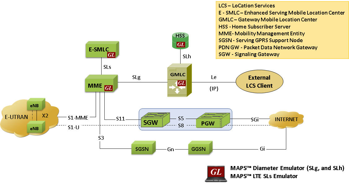
Location Services (LCS) Network Architecture
Overview
The LCS architecture in LTE is similar to GSM/UMTS network, and follows a client/server model with the positioning functionality distributed across LTE radio nodes, eNodeBs, Mobile Management Entity (MME), Evolved-Serving Mobile Location Center (E-SMLC) and Gateway Mobile Location Center (GMLC). As depicted in the diagram above, some of the important interfaces participating in the location request and response in LTE network are summarized below-
- SLs interface - MME is accessible to the E-SMLC via the SLs interface using LCS-AP protocol
- SLg interface - MME is accessible to the GMLC via the SLg interface using Diameter protocol
- SLh interface - HSS is accessible to the GMLC via the SLh interface using Diameter protocol
LTE operates two positioning protocols via the radio network: LTE Positioning Protocol (LPP) and LPP Annex (LPPa). LPP protocol supports hybrid positioning method, in which two or more position methods are used simultaneously to provide accurate measurements. The LTE Positioning Protocols (LPP and LPPa) are carried in LCS-AP PDUs over established SCTP session between an E-SMLC and MME.
Location estimation uses hybrid positioning methodologies from the list of positioning methods given below. These positioning methods may be UE-based, network-based, UE-assisted, network-assisted and/or combination of these methods. The main difference is that the network-based measurements do their calculations at the infrastructure, while the UE based measurements do their calculations at the device.
The standard positioning methods used in LTE network are:
- Enhanced Cell-ID (network based, handset assisted)
- OTDOA positioning method (network based, handset assisted)
- UTDOA positioning method (network based)
- A-GNSS based positioning methods (handset based, network-assisted)
For further details on positioning methods, refer to User Equipment (UE) positioning in E-UTRAN.
Simulation of LCS Procedures using MAPS™
GL’s MAPS™ LCS test suite comprises of multiple products that work in tandem to support simulation of location services on LTE networks and is briefly discussed below.
To support simulation of location services in LTE network, the MAPS™ SLs interface emulator supports LCS procedures over SLs interface between MME and E-SMLC using LCS-AP signaling protocol. Also, MAPS™ Diameter is enhanced to simulate LCS procedures over SLg, and SLh interfaces using Diameter protocol.
GL's MAPS™ supports simulation of different Positioning methods and Position Estimation of a Mobile Stations (MS) in universal coordinates. The estimate is expressed in terms of the geographical shapes and is composed of the type of shape plus the encoding of the shape itself. The Location Estimate parameters such as Type of Shape and coordinates can be input through conventional user profiles or can be fetched from a CSV file every time it sends the location estimate to the client. This selection is to be made by the user.
If the selection is 'Profile' all the values present in the particular profile will be sent in the message response. If the selection is made as ‘CSV’, an entry from the csv file is loaded and all the values from the fetched record will be sent in the message response.
These coordinates indicate different position of MS at different intervals of time and report is sent either periodically at specified time duration or at once when requested.
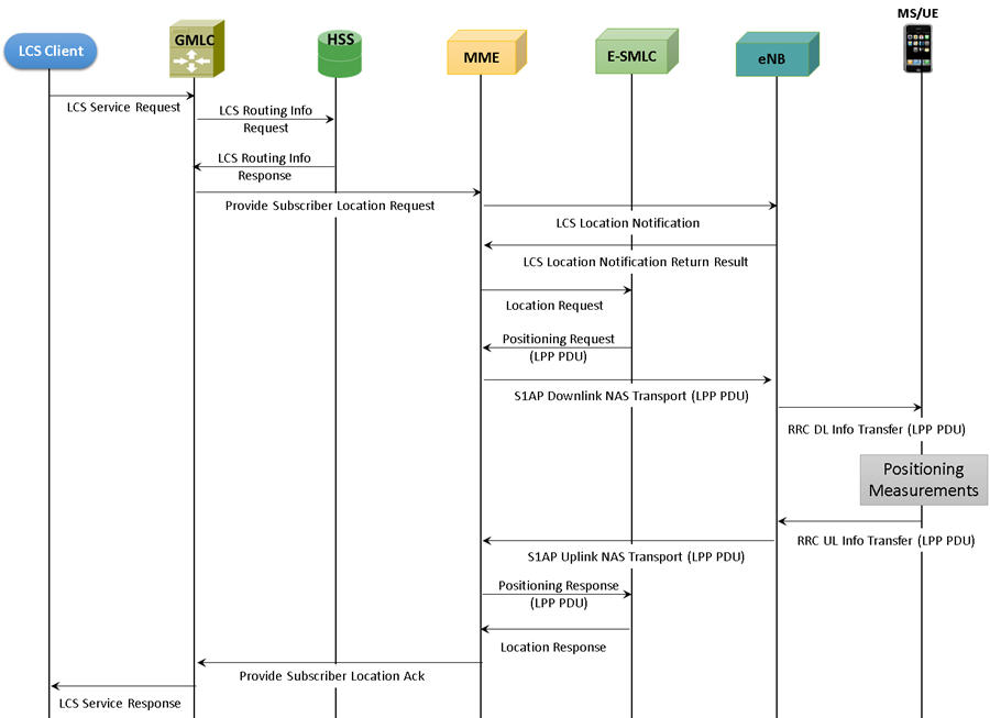
Typical call flow simulation of location based services messages by MAPS™ is as shown below -
In LTE, Evolved-SMLC is attached to MME. Typically, either an LCS client or GMLC sends request to MME. MME then sends location services request to an ESMLC. The E-SMLC acknowledges request, decides on the positioning method to use, interacts with UE or eNodeB to obtain the target location estimate, and then returns the result of the location service back to the MME. In the case of a location service requested by an entity other than the MME (e.g., UE or E-SMLC), the MME returns the location service result to this entity.

Complete Call Flow of LCS Procedures with MAPS™ SLs, and MAPS™ Diameter (SLg, SLh) Emulators
SLs Interface
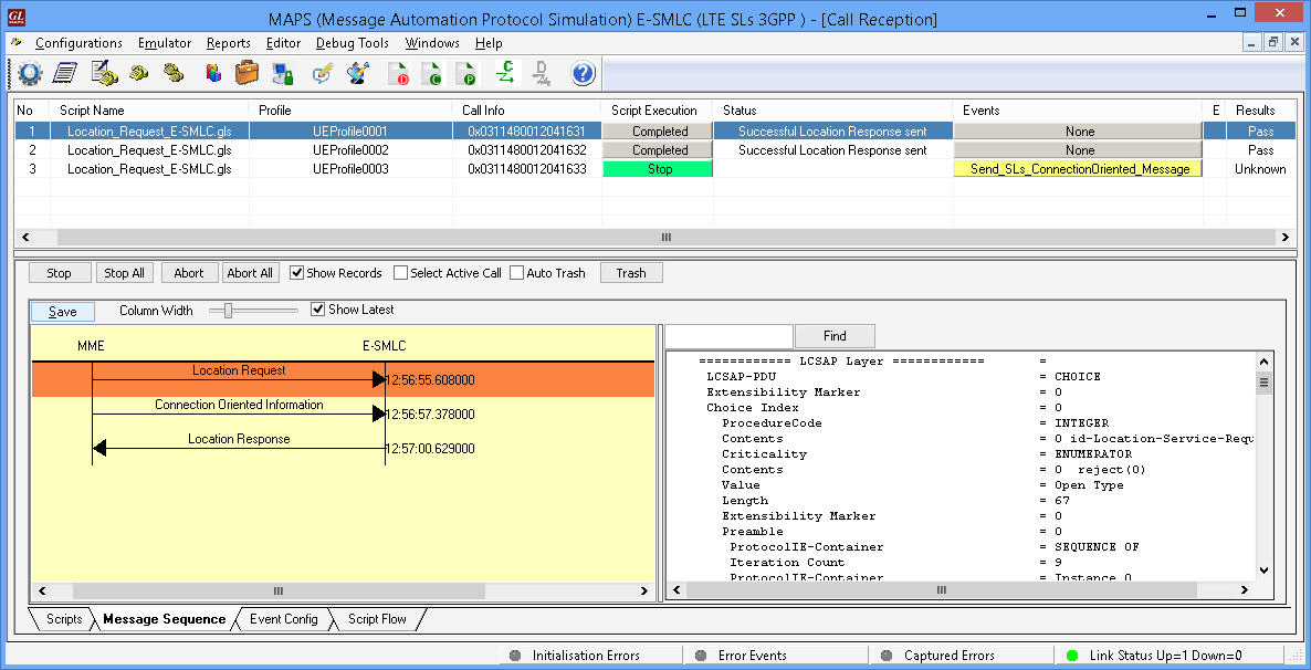
MAPS™ SLs (E-SMLC) simulating SLs interface procedure
MAPS™ SLs interface emulator can simulate LCS network elements supporting positioning procedures over SLs interface between E-SMLC and MME.
LCS Application Protocol (LCS-AP) is a logical interface between the MME and the E-SMLC supporting the location services in E-UTRAN. The LTE Positioning Protocols (LPP and LPPa) can be carried in LCS-AP messages which are transparent to the MME.
MAPS™ SLs supports LCS-AP interface procedures, which are divided as follows:
- Location Service Request - The MME sends a LCS-AP Location Request message to the E-SMLC associated with the current serving cell for the target UE to obtain the location estimate for a target UE in E-UTRAN
- Location Information Exchange - purpose is to two-way transfer of LPP and LPPa messages between a E-SMLC and an MME
- Location Abort procedure - procedure is used by one endpoint to notify the other endpoints to abort an ongoing procedure
- Reset procedure - procedure enables an E-SMLC or a MME that has undergone a failure with loss of location service transactions to indicate this to a partner entity. The recipient entity can then release its own connection and transaction resources
The following screenshot depicts MAPS™ SLs configured as E-SMLC simulating SLs interface LCS procedure.
SLg, SLh Interfaces
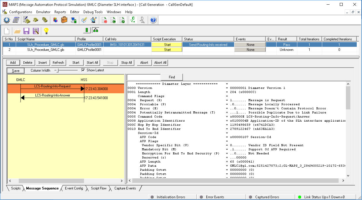
MAPS™ Diameter (GMLC) simulating SLh interface procedure
MAPS™ Diameter supports both server and client simulation exchanging LCS messages over Diameter SLg (between the GMLC and the MME), and SLh interfaces (between GMLC and HSS). The SLg and SLh interface application implements the following Mobile Application Services:
- Provide Subscriber Location - Provide Subscriber Location operation used by a GMLC to request the location of a target UE from the MME
- Subscriber Location Report - Subscriber Location Report operation used by an MME or SGSN to provide the location of a target UE to a GMLC when a request for location has been implicitly issued
- Location Routing Info - The procedure is invoked by the GMLC and is used to retrieve routing information for LCS of a specified user from HSS
The following screenshot depicts MAPS™ Diameter configured as GMLC simulating SLh interface LCS procedure.
 Back to Newsletter Index Page