Microwave and Radio Propagation
Radio propagation and microwave path study
Client: Many Cellular and Land-Mobile Radio System Owners including MTA-Baltimore
Project Services and Objectives:
- Radio Propagation Studies: GL has developed several tools for providing Radio Frequency (RF) Coverage Prediction plots / maps for Cellular, PCS and Land Mobile Radio Systems. In designing a radio system, it is important to predict the RF coverage based on proposed radio system requirements to determine whether the intended objectives can be met.
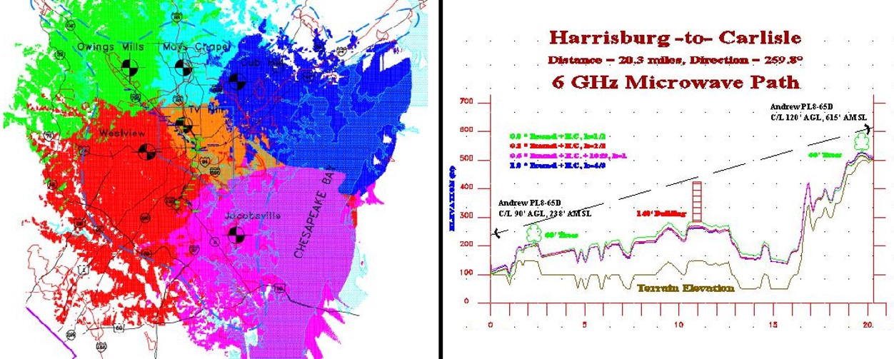
- Median Field Strength Predictions: A sophisticated tool that predicts RF Coverage of a radio system in a prescribed area – At each terrain point median field strength receive signal level is calculated based on a propagation model. This tool may be used for a single or multiple radio sites to indicate the receive signal level by displaying with different colors different ranges (e.g. > -65 dBm, -65 dBm to -80 dBm and -80 dBm to -95 dBm).
- Microwave Path Profile: GL’s Path Profile software tool uses topographical information to plot a terrain profile for each path parameters such as frequency, earth curvature, Fresnel diffraction. A first step in microwave path design is positioning microwave antennas to form a line-of-site connection between two stations. Curvature of the earth, terrain elevation, buildings and trees must all be taken into consideration when planning the microwave link. Intrusions into the signal path by terrain, trees, buildings, or other obstacles can degrade the signal quality by causing signal attenuation and reflection or refraction of the signal. A path profile provides information on where interference might occur and aids in selecting an appropriate path and antenna height.